

Vaige: Difference between revisions
Content deleted Content added
mNo edit summary |
RodRabelo7 (talk | contribs) |
||
| (12 intermediate revisions by 7 users not shown) | |||
| Line 1: | Line 1: | ||
{{Short description|River in France}} |
|||
{{Infobox river |
{{Infobox river |
||
| name = Vaige |
| name = Vaige |
||
| image = Vauv%C3%A9ron_20131208_102255.jpg |
| image = Vauv%C3%A9ron_20131208_102255.jpg |
||
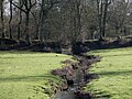
| image_caption = Vaige river at the south of La Bazouge-de-Chemeré in winter |
| image_caption = Vaige river at the south of La Bazouge-de-Chemeré in winter |
||
| pushpin_map = France#France Pays de la Loire |
|||
| source1_location = Saint-Léger |
| source1_location = Saint-Léger |
||
| source1_coordinates= {{coord|48|04|52|N|00|28|15|W}} |
| source1_coordinates= {{coord|48|04|52|N|00|28|15|W}} |
||
| Line 16: | Line 18: | ||
| basin_size = {{convert|233|km2|sqmi|abbr=on}} |
| basin_size = {{convert|233|km2|sqmi|abbr=on}} |
||
}} |
}} |
||
The '''Vaige''' ({{ |
The '''Vaige''' ({{IPA|fr|vɛʒ}}) is a {{convert|53.6|km|mi|abbr=on}} long river in the [[Mayenne]] and [[Sarthe]] [[departments of France|departments]] in western France.<ref name=sandre>{{Sandre|id=M06-0310|nom=Vaige}}</ref> |
||
This list is ordered from source to mouth: |
This list is ordered from source to mouth: |
||
*In Mayenne, the Vaige has its source in [[Saint-Léger, Mayenne|Saint-Léger]] then waters the following villages |
*In Mayenne, the Vaige has its source in [[Saint-Léger, Mayenne|Saint-Léger]] then waters the following villages: [[Vaiges]], [[Saint-Georges-le-Fléchard]], [[La Bazouge-de-Chemeré]], [[La Cropte]], [[Saint-Denis-du-Maine]], [[Préaux, Mayenne|Préaux]], [[Ballée]], [[Beaumont-Pied-de-Bœuf, Mayenne|Beaumont-Pied-de-Bœuf]], |
||
*Then the Vaige séparates Mayenne ([[Saint-Loup-du-Dorat]]) from Sarthe ([[Auvers-le-Hamon]]), |
*Then the Vaige séparates Mayenne ([[Saint-Loup-du-Dorat]]) from Sarthe ([[Auvers-le-Hamon]]), |
||
*Only in Mayenne the Vaige waters [[Bouessay]], |
*Only in Mayenne the Vaige waters [[Bouessay]], |
||
*Entering the Sarthe department, the Vaige avoid the [[Sablé-sur-Sarthe]] town and flows in the [[Sarthe (river)|Sarthe]] ([[right tributary]]) |
*Entering the Sarthe department, the Vaige avoid the [[Sablé-sur-Sarthe]] town and flows in the [[Sarthe (river)|Sarthe]] ([[right tributary]]) |
||
== |
==Low water and flood== |
||
Very often the river uses to dry at the end of summer and the beginning of autumn, so fishes and river mussels die but kingfishers may fly away. |
Very often the river uses to dry at the end of summer and the beginning of autumn, so fishes and river mussels die but kingfishers may fly away.{{cn|date=October 2022}} |
||
<gallery> |
<gallery> |
||
File:Vauvron2005 0917 145324AA.jpg|the Vaige dried at the south of the Bazouge-de-Chemeré on |
File:Vauvron2005 0917 145324AA.jpg|the Vaige dried at the south of the Bazouge-de-Chemeré on September 17, 2005 |
||
File:Vauvron2005 0917 150244AA.jpg|Died fishes in the dried river on 2005 |
File:Vauvron2005 0917 150244AA.jpg|Died fishes in the dried river on 2005 |
||
File:Vauvéron 20170624 161909.jpg|the Vaige dried at the south of the Bazouge-de-Chemeré on |
File:Vauvéron 20170624 161909.jpg|the Vaige dried at the south of the Bazouge-de-Chemeré on June 24, 2017 |
||
File:Vauvéron 20100228 130846 031.jpg|Flood at the south of the Bazouge-de-Chemeré on |
File:Vauvéron 20100228 130846 031.jpg|Flood at the south of the Bazouge-de-Chemeré on February 28, 2010 |
||
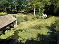
File:Vauvéron_20100130_115341_003.jpg|The Chemerette stream passes through an old path before flowing in Vaige river. |
File:Vauvéron_20100130_115341_003.jpg|The Chemerette stream passes through an old path before flowing in Vaige river. |
||
File:Vauvéron 20090913 114148 09.jpg|Wash-house in La Cropte |
File:Vauvéron 20090913 114148 09.jpg|Wash-house in La Cropte |
||
</gallery> |
</gallery> |
||
== Notes == |
|||
*''This article is based on the [[:fr:Vaige]] from the [[French Wikipedia]], consulted on March 22nd 2009.'' |
|||
==References== |
==References== |
||
{{Reflist}} |
{{Reflist}} |
||
*http://www.geoportail.fr |
|||
[[Category:Rivers of France]] |
[[Category:Rivers of France]] |
||
Latest revision as of 16:49, 25 August 2024
| Vaige | |
|---|---|
 Vaige river at the south of La Bazouge-de-Chemeré in winter | |
  | |
| Location | |
| Country | France |
| Physical characteristics | |
| Source | |
| • location | Saint-Léger |
| • coordinates | 48°04′52″N 00°28′15″W / 48.08111°N 0.47083°W |
| • elevation | 112 m (367 ft) |
| Mouth | |
• location | Sarthe |
• coordinates | 47°50′15″N 00°19′55″W / 47.83750°N 0.33194°W |
• elevation | 24 m (79 ft) |
| Length | 53.6 km (33.3 mi) |
| Basin size | 233 km2 (90 sq mi) |
| Discharge | |
| • average | 1.48 m3/s (52 cu ft/s) |
| Basin features | |
| Progression | Sarthe→ Maine→ Loire→ Atlantic Ocean |
The Vaige (French pronunciation: [vɛʒ]) is a 53.6 km (33.3 mi) long river in the Mayenne and Sarthe departments in western France.[1]
This list is ordered from source to mouth:
- In Mayenne, the Vaige has its source in Saint-Léger then waters the following villages: Vaiges, Saint-Georges-le-Fléchard, La Bazouge-de-Chemeré, La Cropte, Saint-Denis-du-Maine, Préaux, Ballée, Beaumont-Pied-de-Bœuf,
- Then the Vaige séparates Mayenne (Saint-Loup-du-Dorat) from Sarthe (Auvers-le-Hamon),
- Only in Mayenne the Vaige waters Bouessay,
- Entering the Sarthe department, the Vaige avoid the Sablé-sur-Sarthe town and flows in the Sarthe (right tributary)
Low water and flood
[edit]Very often the river uses to dry at the end of summer and the beginning of autumn, so fishes and river mussels die but kingfishers may fly away.[citation needed]
-
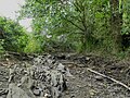
 the Vaige dried at the south of the Bazouge-de-Chemeré on September 17, 2005
 -
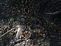 Died fishes in the dried river on 2005
 -
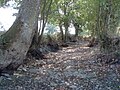
 the Vaige dried at the south of the Bazouge-de-Chemeré on June 24, 2017
 -
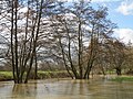 Flood at the south of the Bazouge-de-Chemeré on February 28, 2010
 -
 The Chemerette stream passes through an old path before flowing in Vaige river.
 -
 Wash-house in La Cropte


References
[edit]
This Mayenne geographical article is a stub. You can help Wikipedia by expanding it. |
This Sarthe geographical article is a stub. You can help Wikipedia by expanding it. |