

Vaige: Difference between revisions
Content deleted Content added
mNo edit summary |
GoingBatty (talk | contribs) m clean up, typo(s) fixed: june → June, february → February, september → September, october → October |
||
| Line 27: | Line 27: | ||
Very often the river uses to dry at the end of summer and the beginning of autumn, so fishes and river mussels die but kingfishers may fly away. |
Very often the river uses to dry at the end of summer and the beginning of autumn, so fishes and river mussels die but kingfishers may fly away. |
||
<gallery> |
<gallery> |
||
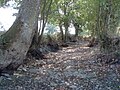
File:Vauvron2005 0917 145324AA.jpg|the Vaige dried at the south of the Bazouge-de-Chemeré on |
File:Vauvron2005 0917 145324AA.jpg|the Vaige dried at the south of the Bazouge-de-Chemeré on September 17, 2005 |
||
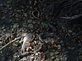
File:Vauvron2005 0917 150244AA.jpg|Died fishes in the dried river on 2005 |
File:Vauvron2005 0917 150244AA.jpg|Died fishes in the dried river on 2005 |
||
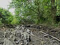
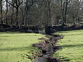
File:Vauvéron 20170624 161909.jpg|the Vaige dried at the south of the Bazouge-de-Chemeré on |
File:Vauvéron 20170624 161909.jpg|the Vaige dried at the south of the Bazouge-de-Chemeré on June 24, 2017 |
||
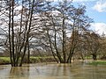
File:Vauvéron 20100228 130846 031.jpg|Flood at the south of the Bazouge-de-Chemeré on |
File:Vauvéron 20100228 130846 031.jpg|Flood at the south of the Bazouge-de-Chemeré on February 28, 2010 |
||
File:Vauvéron_20100130_115341_003.jpg|The Chemerette stream passes through an old path before flowing in Vaige river. |
File:Vauvéron_20100130_115341_003.jpg|The Chemerette stream passes through an old path before flowing in Vaige river. |
||
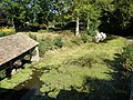
File:Vauvéron 20090913 114148 09.jpg|Wash-house in La Cropte |
File:Vauvéron 20090913 114148 09.jpg|Wash-house in La Cropte |
||
| Line 36: | Line 36: | ||
== Notes == |
== Notes == |
||
*''This article is based on the [[:fr:Vaige]] from the [[French Wikipedia]], consulted on March |
*''This article is based on the [[:fr:Vaige]] from the [[French Wikipedia]], consulted on March 22, 2009.'' and illustrated on October 10, 2019 |
||
==References== |
==References== |
||
Revision as of 04:50, 10 January 2020
| Vaige | |
|---|---|
 Vaige river at the south of La Bazouge-de-Chemeré in winter | |
| Location | |
| Country | France |
| Physical characteristics | |
| Source | |
| • location | Saint-Léger |
| • coordinates | 48°04′52″N 00°28′15″W / 48.08111°N 0.47083°W |
| • elevation | 112 m (367 ft) |
| Mouth | |
• location | Sarthe |
• coordinates | 47°50′15″N 00°19′55″W / 47.83750°N 0.33194°W |
• elevation | 24 m (79 ft) |
| Length | 53.6 km (33.3 mi) |
| Basin size | 233 km2 (90 sq mi) |
| Discharge | |
| • average | 1.48 m3/s (52 cu ft/s) |
| Basin features | |
| Progression | Sarthe→ Maine→ Loire→ Atlantic Ocean |
The Vaige (French: la Vaige) is a 53.6 km (33.3 mi) long river in the Mayenne and Sarthe departments in western France.[1]
This list is ordered from source to mouth:
- In Mayenne, the Vaige has its source in Saint-Léger then waters the following villages : Vaiges, Saint-Georges-le-Fléchard, La Bazouge-de-Chemeré, La Cropte, Saint-Denis-du-Maine, Préaux, Ballée, Beaumont-Pied-de-Bœuf,
- Then the Vaige séparates Mayenne (Saint-Loup-du-Dorat) from Sarthe (Auvers-le-Hamon),
- Only in Mayenne the Vaige waters Bouessay,
- Entering the Sarthe department, the Vaige avoid the Sablé-sur-Sarthe town and flows in the Sarthe (right tributary)
low water and flood
Very often the river uses to dry at the end of summer and the beginning of autumn, so fishes and river mussels die but kingfishers may fly away.
-
 the Vaige dried at the south of the Bazouge-de-Chemeré on September 17, 2005
 -
 Died fishes in the dried river on 2005
 -
 the Vaige dried at the south of the Bazouge-de-Chemeré on June 24, 2017
 -
 Flood at the south of the Bazouge-de-Chemeré on February 28, 2010
 -
 The Chemerette stream passes through an old path before flowing in Vaige river.
 -
 Wash-house in La Cropte


Notes
- This article is based on the fr:Vaige from the French Wikipedia, consulted on March 22, 2009. and illustrated on October 10, 2019
References
This Mayenne geographical article is a stub. You can help Wikipedia by expanding it. |
This Sarthe geographical article is a stub. You can help Wikipedia by expanding it. |