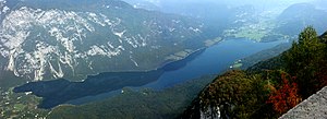
Llac Bohinj
Aparença
| (sl) Bohinjsko jezero | ||||
| Tipus | llac llac glacial | |||
|---|---|---|---|---|
| Localitzat a l'àrea protegida | Parc Nacional de Triglav | |||
| Localització | ||||
| País de la conca | Eslovènia | |||
| Entitat territorial administrativa | Eslovènia | |||
| ||||
| Banyat per | Sava Bohinjka (en) | |||
| Afluents | ||||
| Efluent | Sava Bohinjka (en) | |||
| Conca hidrogràfica | conca del Danubi | |||
| Característiques | ||||
| Altitud | 526 m | |||
| Profunditat | 45 m | |||
| Dimensió | 1.200 ( | |||
| Superfície | 3,18 km² | |||
| Mesures | ||||
| Volum | 92.500.000 m³ | |||
El llac Bohinj (Bohinjsko jezero) està situat als Alps Julians al nord-oest d'Eslovènia, molt a prop del llac Bled i de la frontera amb Itàlia i Àustria, dins el Parc Nacional de Triglav.
El llac Bohinj és el llac natural més gran d'Eslovènia.[1] Les seves dimensions són de 4.350 m de llarg, i 1.250 m d'ample, tenint la seva màxima profunditat a 45 m.[2] El llac és d'origen glacial embassat per una morena. El més gran dels rierols que desemboquen al llac és el Savica.[3] A la part del nord del llac hi trobem unes quantes fonts submarines, la més coneguda és la font de Govic.
Referències
[modifica]- ↑ «Characteristics of Biological and Landscape Diversity in Slovenia». A: Hlad, Branka. Biological and Landscape Diversity in Slovenia: An Overview. Ljubljana: Environmental Agency of the Republic of Slovenia, Ministry of the Environment and Spatial Planning, 2001, p. 13. ISBN 961-6324-17-9. Arxivat 2012-11-25 a Wayback Machine.
- ↑ Royal Geographical Society (1856) "Wocheiner-See" A Gazetteer of the World: or, Dictionary of geographical knowledge, compiled from the most recent authorities, and forming a complete body of modern geography -- physical, political, statistical, historical, and ethnographical A. Fullarton, Edinburgh, Scotland, p. 529, OCLC 20348227; note that Lake Bohinj was formerly known in English by its German name Wocheiner See, or sometimes Lake Wochein.
- ↑ Baedeker, Karl (1879) "Terglou: The Valley of the Wocheiner Save" The Eastern Alps: Including the Bavarian Highlands, the Tyrol, Salzkammergut, Styria, and Carinthia (4th ed.) Dulau and Co., London, p. 353, OCLC 4018143

