The Lys (Walser German: Liisu or Lyesu) is a small 40 kilometres (25 mi) river (classified as a torrente).
| Lys | |
|---|---|
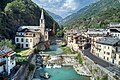
 The Lys at Gressoney-Saint-Jean | |
 | |
| Location | |
| Country | Italy |
| Physical characteristics | |
| Source | |
| • location | Monte Rosa |
| • coordinates | 45°53′00″N 7°48′40″E / 45.88333°N 7.81111°E |
| • elevation | 2,500 m (8,200 ft) |
| Mouth | Dora Baltea |
• coordinates | 45°35′24″N 7°47′33″E / 45.5900°N 7.7925°E |
| Length | 40 km (25 mi) |
| Basin features | |
| Progression | Dora Baltea→ Po→ Adriatic Sea |
Geography
editIt flows from the Lys Glacier on the south side of the Monte Rosa massif, at the foot of Vincent Pyramid, elevation 4,215 metres (13,829 ft), and runs through the Gressoney Valley, flanked by a road, through the following municipalities:
It converges with the Dora Baltea (fr. Doire baltée) as a right tributary at Pont-Saint-Martin.
Its left-side tributaries are Avant-Cir, Glassit, Loo, Mos, Niel, Pacoulla, and Tourrison. From the right it receives: Rû de Nantay, Stolen and Valbona.
Gallery
edit-
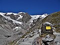 The sources of the Lys at the Lys glacier in the Monte Rosa mountain massif, below the Vincent Pyramid and close to the giant Lyskamm (4.533 m)
 -
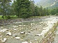 The river close to Gaby
 -
-
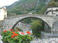
 In Fontainemore


This article on a location in Aosta Valley is a stub. You can help Wikipedia by expanding it. |