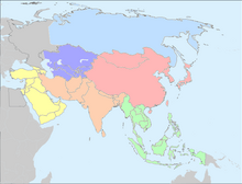
The United Nations geoscheme for Asia is an internal tool created and used by the United Nations, maintained by the United Nations Statistics Division (UNSD) for the specific purpose of UN statistics.[1] The scheme's subregions are presented here in alphabetical order. Its subregions may not coincide with other geographic categorization schemes.

Central Asia
editEastern Asia
editNote on Taiwan
editSeveral institutions and research papers using classification schemes based on the UN geoscheme include Taiwan separately in their divisions of Eastern Asia.
- The Unicode CLDR's "Territory Containment (UN M.49)" includes Taiwan in its presentation of the UN M.49.[2]
- The public domain map data set Natural Earth has metadata in the fields named "region_un" and "subregion" for Taiwan.
- The regional split recommended by Lloyd's of London for Eastern Asia (UN statistical divisions of Eastern Asia) contains Taiwan.[3]
- Based on the United Nations statistical divisions, the APRICOT (conference) includes Taiwan in East Asia.[4]
- Studying Website Usability in Asia, Ather Nawaz and Torkil Clemmensen select Asian countries on the basis of United Nations statistical divisions, and Taiwan is also included.[5]
- Taiwan is also included in the UN Geoscheme of Eastern Asia in one systematic review on attention deficit hyperactivity disorder.[6]
Northern Asia
editThis subregion covers the entire geographical region of Siberia. Since this region as a whole falls under the transcontinental country of Russia, for statistical convenience, Russia is assigned under Eastern Europe by the UNSD, including both European Russia and Asian Russia under a single subregion. Hence there is no geopolitical entity that is currently grouped under Northern Asia.
South-eastern Asia
editThis subregion covers the geographical regions of Indochinese Peninsula and Malay Archipelago, covering the following geopolitical entities as a whole:
Southern Asia
editThis subregion covers the geographical regions spanning from the Iranian Plateau till the Indian subcontinent, covering the following geopolitical entities as a whole:
Western Asia
editThis subregion covers the geographical regions spanning from Anatolia, Caucasus, Levant, Mesopotamia till the Arabian Peninsula, covering the following geopolitical entities as a whole:
See also
edit- List of subregions of Asia in geographical terms: Subregion: Asia
- List of continents and continental subregions by population
- List of countries by United Nations geoscheme
- United Nations geoscheme
- United Nations geoscheme for Africa, the Americas, Europe, and Oceania
- United Nations Statistics Division
References
edit- ^ United Nations Statistics Division – Standard Country and Area Codes Classifications. The UNSD notes that "the assignment of countries or areas to specific groupings is for statistical convenience".
- ^ "Territory Containment (UN M.49)". unicode-org.github.io.
- ^ "Geographical diversification and Solvency II: A proposal by Lloyd's".
- ^ "Countries in APRICOT's Region".
- ^ Website Usability in Asia 'from Within': An Overview of a Decade of Literature International Journal of Human-Computer Interaction, vol. 29, issue 4 (2013), pp. 256–273.
- ^ Hodgkins, Paul; Arnold, L. Eugene; Shaw, Monica; Caci, Hervé; Kahle, Jennifer; Woods, Alisa G; Young, Susan (2012). "A Systematic Review of Global Publication Trends Regarding Long-Term Outcomes of ADHD". Frontiers in Psychiatry. 2: 84. doi:10.3389/fpsyt.2011.00084. ISSN 1664-0640. PMC 3260478. PMID 22279437.