Arrondissement of Ath
Appearance
Arrondissement of Ath
Arrondissement d'Ath | |
|---|---|
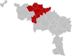
 Location of the arrondissement in Hainaut | |
| Coordinates: 50°36′N 3°45′E / 50.6°N 3.75°E | |
| Country | |
| Region | |
| Province | |
| Municipalities | 11 |
| Area | |
| • Total | 667.94 km2 (257.89 sq mi) |
| Population (1 January 2017) | |
| • Total | 86,719 |
| • Density | 130/km2 (340/sq mi) |
| Time zone | UTC+1 (CET) |
| • Summer (DST) | UTC+2 (CEST) |
The Arrondissement of Ath (French: Arrondissement d'Ath; Dutch: Arrondissement Aat) is one of the seven administrative arrondissements in the Walloon province of Hainaut, Belgium. It is not a judicial arrondissement. Two of its municipalities, Brugelette and Chièvres, are part of the Judicial Arrondissement of Mons, while the others are part of the Judicial Arrondissement of Tournai.[1]
Municipalities
[edit]The Administrative Arrondissement of Ath consists of the following municipalities:
Since 2019
[edit]- Ath
- Belœil
- Bernissart
- Brugelette
- Chièvres
- Ellezelles
- Enghien
- Flobecq
- Frasnes-lez-Anvaing
- Lessines
- Silly
Before 2019
[edit]The three municipalities of the Arrondissement of Soignies (Enghien, Lessines and Silly) are integrated into the Arrondissement of Ath on January 1, 2019.
References
[edit]- ^ "Moniteur Belge - Belgisch Staatsblad". archive.wikiwix.com. Retrieved 2022-12-23.