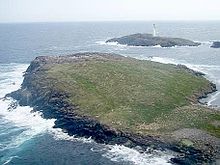
Grunay
Appearance

| Location | Grunay, United Kingdom |
|---|---|
| Tower | |
| Constructed | 1854 |
| Light | |
| First lit | 15 September 1854 |
| Deactivated | 1858 |
Grunay is an uninhabited island in the Out Skerries group, the most easterly part of Shetland, Scotland. Its area is 55.58 acres,[1] or 22.49 hectares.
The island is the site of the lighthouse keeper's house for the lighthouse on the nearby Bound Skerry. This house was abandoned following the automation of the light in 1972.[2]
A Blenheim IV bomber from No. 404 Squadron RCAF crashed on the south side of the island on the morning of 21 February 1942, possibly crippled by enemy fire off the coast of Norway. A plaque was placed on the island in 1990 to commemorate the crew by the nephew of one of the three men who died.[3]
See also
[edit]References
[edit]- ^ https://media.onthemarket.com/properties/1891065/doc_0_0.pdf [bare URL PDF]
- ^ "Out Skerries Lighthouse " Archived 2016-03-03 at the Wayback Machine NLB. Retrieved 29 December 2008.
- ^ "Shetland Crash Log " crcshetland.co.uk. Retrieved 29 December 2008.
Wikimedia Commons has media related to Grunay.
60°25′19″N 0°44′24″W / 60.422°N 0.740°W