Kfar Shmuel
Appearance
Kfar Shmuel
כְּפַר שְׁמוּאֵל | |
|---|---|
 | |
| Coordinates: 31°53′22″N 34°55′54″E / 31.88944°N 34.93167°E | |
| Country | |
| District | Central |
| Council | Gezer |
| Affiliation | HaOved HaTzioni |
| Founded | 4 January 1950 |
| Founded by | Romanian-Jewish immigrants |
| Population (2022)[1] | 971 |
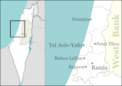
Kfar Shmuel (Hebrew: כְּפַר שְׁמוּאֵל, lit. 'Shmuel Village') is a moshav in central Israel. Located in the Shephelah around six kilometres south of Ramle, it falls under the jurisdiction of Gezer Regional Council. In 2022 it had a population of 971.[1]
History
[edit]The moshav was founded on 4 January 1950 by immigrants from Romania on the land of the depopulated Palestinian village of Innaba,[2] which was occupied by Israeli forces on 10 July 1948. It was named after Stephen Samuel (Shmuel) Wise, an American Reform rabbi and Zionist leader.
See also
[edit]References
[edit]- ^ a b "Regional Statistics". Israel Central Bureau of Statistics. Retrieved 21 March 2024.
- ^ Khalidi, Walid (1992). All That Remains: The Palestinian Villages Occupied and Depopulated by Israel in 1948. Washington D.C.: Institute for Palestine Studies. p. 384. ISBN 0-88728-224-5.
Wikimedia Commons has media related to Kfar Shmuel.
