Koeru Parish
Appearance
Koeru Parish
Koeru vald | |
|---|---|
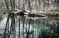
 Blue Springs at Endla Nature Reserve | |
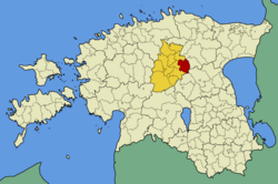
 Koeru Parish within Järva County. | |
| Country | |
| County | |
| Administrative centre | Koeru |
| Area | |
| • Total | 236.82 km2 (91.44 sq mi) |
| Population (2003) | |
| • Total | 2,465 |
| • Density | 10/km2 (27/sq mi) |
| Website | www.koeruvv.ee |
Koeru Parish (Estonian: Koeru vald) was a rural municipality in Järva County, Estonia.[1]
Settlements
[edit]1 small borough: Koeru.
26 villages: Abaja, Aruküla, Ervita, Jõeküla, Kalitsa, Kapu, Koidu-Ellavere, Kuusna, Laaneotsa, Liusvere, Merja, Norra, Preedi, Puhmu, Rõhu, Salutaguse, Santovi, Tammiku, Tudre, Udeva, Vahuküla, Väinjärve, Valila, Vao, Visusti and Vuti.
See also
[edit]References
[edit]- ^ "X-GIS(4) Portal". xgis.maaamet.ee. Retrieved 31 January 2022.
External links
[edit]- Official website (in Estonian)
58°58′00″N 26°02′00″E / 58.966667°N 26.033333°E

