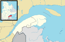
Lac-des-Eaux-Mortes, Quebec
Appearance
Lac-des-Eaux-Mortes | |
|---|---|
 Location within La Mitis RCM. | |
| Coordinates: 48°14′N 68°05′W / 48.233°N 68.083°W[1] | |
| Country | |
| Province | |
| Region | Bas-Saint-Laurent |
| RCM | La Mitis |
| Established | March 13, 1986 |
| Government | |
| • Federal riding | Haute-Gaspésie—La Mitis—Matane—Matapédia |
| • Prov. riding | Matane-Matapédia |
| Area | |
• Total | 954.82 km2 (368.66 sq mi) |
| • Land | 923.26 km2 (356.47 sq mi) |
| Population (2021)[3] | |
• Total | 47 |
| • Density | 0.1/km2 (0.3/sq mi) |
| • Pop 2026-2021 | |
| • Dwellings | 202 |
| Time zone | UTC−5 (EST) |
| • Summer (DST) | UTC−4 (EDT) |
| Highways | No major routes |
Lac-des-Eaux-Mortes (French pronunciation: [lak dez‿o mɔʁt], lit. 'Lake of the Dead Waters') is an unorganized territory in the Canadian province of Quebec, located in the La Mitis Regional County Municipality.
See also
[edit]- Patapédia River
- East Patapédia River
- La Mitis Regional County Municipality
- List of unorganized territories in Quebec
References
[edit]- ^ "Banque de noms de lieux du Québec: Reference number 149689". toponymie.gouv.qc.ca (in French). Commission de toponymie du Québec.
- ^ a b "Répertoire des municipalités: Geographic code 09902". www.mamh.gouv.qc.ca (in French). Ministère des Affaires municipales et de l'Habitation.
- ^ a b "Data table, Census Profile, 2021 Census of Population - Lac-des-Eaux-Mortes, Unorganized (NO) [Census subdivision], Quebec". 9 February 2022.
