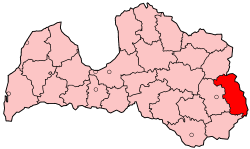
Ludza District
Appearance
Ludza | |
|---|---|
District | |
 | |
| Country | Latvia |
| Area | |
| • Total | 2,412 km2 (931 sq mi) |
| Population | |
| • Total | 32,634 |
| • Density | 14/km2 (35/sq mi) |
| Website | ludza.lv/ |
Ludza District (Latvian: Ludzas rajons) was an administrative division of Latvia, located in Latgale region, in the country's east.
Districts were eliminated during the administrative-territorial reform in 2009.
Towns of Ludza District
[edit]Provinces and parishes of Ludza District
[edit]- Blonti parish
- Brigi parish
- Cibla municipality
- Cirma parish
- Goliševa parish
- Isnauda parish
- Istra parish
- Lauderi parish
- Malnava parish
- Mērdzene parish
- Mežvidi parish
- Nirza parish
- Ņukši parish
- Pasiene parish
- Pilda parish
- Pureņi parish
- Pušmucova parish
- Rundēni parish
- Salnava parish
- Zilupe municipality
- Zvirgzdene parish
56°33′N 27°43′E / 56.550°N 27.717°E