Makoua
Appearance
Makoua | |
|---|---|
| Coordinates: 0°0′24″S 15°37′5″E / 0.00667°S 15.61806°E | |
| Country | |
| Department | Cuvette |
| District | Makoua |
| Population (2023 census)[1] | |
• Total | 34,408 |
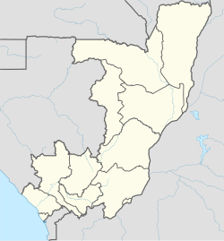
Makoua is a town in the Republic of the Congo, lying on the equator at the southern edge of the rainforest, north of Owando. It is the seat of the Makoua District in the Cuvette Department.
It is home to an airport.
Climate
[edit]Makouas has a tropical rainforest climate (Af), with heavy rainfall year-round.
| Climate data for Makoua (1955-2022) | |||||||||||||
|---|---|---|---|---|---|---|---|---|---|---|---|---|---|
| Month | Jan | Feb | Mar | Apr | May | Jun | Jul | Aug | Sep | Oct | Nov | Dec | Year |
| Record high °C (°F) | 35.3 (95.5) |
39.0 (102.2) |
37.0 (98.6) |
36.0 (96.8) |
40.1 (104.2) |
36.0 (96.8) |
33.2 (91.8) |
34.0 (93.2) |
34.9 (94.8) |
35.8 (96.4) |
39.2 (102.6) |
35.5 (95.9) |
40.1 (104.2) |
| Mean daily maximum °C (°F) | 29.2 (84.6) |
30.1 (86.2) |
30.5 (86.9) |
30.3 (86.5) |
29.9 (85.8) |
28.4 (83.1) |
27.2 (81.0) |
27.9 (82.2) |
28.6 (83.5) |
29.3 (84.7) |
29.3 (84.7) |
28.9 (84.0) |
29.1 (84.4) |
| Daily mean °C (°F) | 24.8 (76.6) |
25.4 (77.7) |
25.6 (78.1) |
25.6 (78.1) |
25.4 (77.7) |
24.3 (75.7) |
23.4 (74.1) |
23.9 (75.0) |
24.4 (75.9) |
24.9 (76.8) |
24.8 (76.6) |
24.6 (76.3) |
24.8 (76.6) |
| Mean daily minimum °C (°F) | 20.4 (68.7) |
20.6 (69.1) |
20.8 (69.4) |
20.9 (69.6) |
20.8 (69.4) |
20.2 (68.4) |
19.6 (67.3) |
20.0 (68.0) |
20.3 (68.5) |
20.4 (68.7) |
20.4 (68.7) |
20.3 (68.5) |
20.4 (68.7) |
| Record low °C (°F) | 10.6 (51.1) |
15.6 (60.1) |
17.5 (63.5) |
14.0 (57.2) |
14.5 (58.1) |
13.0 (55.4) |
15.0 (59.0) |
15.2 (59.4) |
12.2 (54.0) |
17.5 (63.5) |
17.8 (64.0) |
15.5 (59.9) |
10.6 (51.1) |
| Average precipitation mm (inches) | 273.0 (10.75) |
269.9 (10.63) |
307.1 (12.09) |
314.1 (12.37) |
298.0 (11.73) |
250.4 (9.86) |
244.3 (9.62) |
274.2 (10.80) |
346.6 (13.65) |
348.0 (13.70) |
292.9 (11.53) |
279.4 (11.00) |
3,497.9 (137.73) |
| Average precipitation days (≥ 1.0 mm) | 11.3 | 11.8 | 13.6 | 14.0 | 14.6 | 11.1 | 9.4 | 11.0 | 14.7 | 17.5 | 14.5 | 12.9 | 156.5 |
| Source: NOAA[2] | |||||||||||||
References
[edit]- ^ "Congo (Rep.): Departments, Major Cities & Urban Localities - Population Statistics, Maps, Charts, Weather and Web Information". www.citypopulation.de. Retrieved 2024-10-19.
- ^ "Daily Summaries Station Details". National Oceanic and Atmospheric Administration. Retrieved February 22, 2022.
