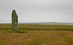
Mor Stein
Appearance

Mor Stein is a neolithic standing stone in the southeastern part of the island of Shapinsay, Orkney Islands, Scotland.[1] Shapinsay is one of the two large inner islands of the Orkney group, and it is situated approximately two miles north of the Orkney Mainland.[2] Linton Bay is situated slightly to the northeast of Mor Stein.
Mor Stein is a vertical standing stone of approximately 3.2 metres (10 ft) in height, which is unshaped and uncarved and stands in a field somewhat separate from any other man-made features of the island.[3] A few miles to the north is Burroughston Broch with its earth cladding intact, allowing visitors to peer down into the broch from above.[4]
See also
[edit]- Balfour Castle – Country house in Orkney, Scotland
- The Ouse – tidal estuary in northern Shapinsay, Orkney Islands, Scotland, UK
References
[edit]- ^ United Kingdom Ordnance Survey Map Landranger Map, Orkney Mainland, 1:50,000 scale, 2002
- ^ J. Gunn, Orkney, the Magnetic North, Thomas Nelson and Sons, Edinburgh (1932)
- ^ C.M Hogan, Natural History of the Orkney Islands, Aberdeen (2006)
- ^ Burroughston Broch on line profile
59°2′12″N 2°49′47″W / 59.03667°N 2.82972°W