

Osolnik, Medvode
Osolnik
Govejek (until 1979) | |
|---|---|
 | |
 Osolnik Location in Slovenia | |
| Coordinates: 46°7′20.43″N 14°20′13.16″E / 46.1223417°N 14.3369889°E | |
| Country | |
| Traditional region | Upper Carniola |
| Statistical region | Central Slovenia |
| Municipality | Medvode |
| Area | |
| • Total | 3.68 km2 (1.42 sq mi) |
| Elevation | 800.5 m (2,626.3 ft) |
| Population (2002) | |
| • Total | 26 |
| [1] | |
Osolnik (pronounced [ɔˈsoːu̯nik]) is a dispersed settlement in the Municipality of Medvode in the Upper Carniola region of Slovenia.[2]
History
[edit]The settlement was created in 1979, when part of the former settlement of Govejek was renamed Osolnik. The remainder of Govejek was annexed to the neighboring settlement of Trnovec.[3]
Church
[edit]
The local church is built on the top of a hill above the settlement. It is dedicated to Saints Hermagoras and Fortunatus.[4]
Gallery
[edit]-
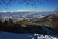 The Kamnik–Savinja Alps seen from Osolnik

References
[edit]- ^ Statistical Office of the Republic of Slovenia
- ^ Medvode municipal site
- ^ Spremembe naselij 1948–95. 1996. Database. Ljubljana: Geografski inštitut ZRC SAZU, DZS.
- ^ "Škofja Loka Tourist association site" (in Slovenian). Archived from the original on 2016-03-04. Retrieved 2008-12-23. Škofja Loka Tourist association site (in Slovene)
External links
[edit] Media related to Osolnik at Wikimedia Commons
- Osolnik on Geopedia
| Settlements | Administrative seat: Medvode
|  | ||||
|---|---|---|---|---|---|---|
| Landmarks | ||||||
This article about the Municipality of Medvode in Slovenia is a stub. You can help Wikipedia by expanding it. |