Zomergem
Appearance
Zomergem | |
|---|---|
Village and former municipality | |
 Zomergem: Market Place and St Martin's church | |
| Coordinates: 51°07′N 03°33′E / 51.117°N 3.550°E | |
| Country | |
| Region | Flemish Region |
| Province | East Flanders |
| Arrondissement | Ghent |
| Municipality | Lievegem |
| Area | |
• Total | 39.29 km2 (15.17 sq mi) |
| Population (2021)[1] | |
• Total | 8,544 |
| • Density | 220/km2 (560/sq mi) |
| Time zone | CET |
| Postal code | 9930-9932 |
| Dialing code | 09 |
| Website | www.lievegem.be |
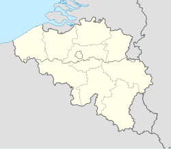
Zomergem (Dutch pronunciation: [ˈzoːmərɣɛm]) is a town and former municipality located in the Flanders and in the province of East Flanders, in Belgium. The municipality comprises the towns of Oostwinkel, Ronsele and Zomergem proper. On 1 January 2018, Zomergem had a total population of 8,466. The total area is 38.78 km2.[2]
Effective 1 January 2019, Waarschoot, Lovendegem and Zomergem were merged into the new municipality of Lievegem.[3]
Gallery
[edit]-
Zomergem, St Martin's church
-
St Martin's church
-
Zomergem, townhall
-
Motjes bridge on the Schipdonk canal
References
[edit]- ^ a b "Bevolking per statistische sector - Sector 44080". Statistics Belgium. Retrieved 6 May 2022.
Includes Ronsele and Oostwinkel
- ^ ""Wettelijke Bevolking per gemeente op 1 januari 2018"". StatBel. Retrieved 9 March 2019.
- ^ "Drie kleintjes zijn liever samen groot: in 2019 worden inwoners wakker in Lievegem". Nieuwsblad (in Dutch). Retrieved 5 May 2022.
External links
[edit] Media related to Zomergem at Wikimedia Commons
- Official website (in Dutch)


