Bestand:Antarctica 6400px from Blue Marble.jpg

Oorspronkelijk bestand (6.400 × 6.400 pixels, bestandsgrootte: 3,31 MB, MIME-type: image/jpeg)

Beschrijving

Beschrijving
العربية: القارَّة القُطبيَّة الجنوبيَّة (أنتاركتيكا). صورة ساتليَّة تابعة لِوكالة ناسا، من ضمن بيانات الگُلَّة الزرقاء المُرسلة عبر الأقمار الاصطناعيَّة (من على بُعد كيلومترٍ واحد من العدسة الساتليَّة المُستخدمة). "تمَّ مزج بينات "MODIS" المُخصصة لِدراسة حالة الجليد القطبي مع تلك الخاصَّة بالإدارة القوميَّة لِدراسة المُحيطات والمُناخ—التي تمَّ الحصول عليها عبر الراديومتر الأكثر تطوُّرًا." تمَّ توليد الصورة باستخدام برنامج C مُخصص للتعامل مع صور وبيانات الگُلَّة الزرقاء، كما تمَّ الحصول على مُعادلات الإسقاط الشاقولي من موقع عالم الرِّياضيَّات.
مُلاحظة: تمَّ تعديل هذه الصورة يدويًّا في سبيل ملء بعض المناطق ذات العُنصورات (الپكسلات) السوداء، في الرُبعيَّة العُليا اليُمنى. يُعتقد بأنَّ تلك العُنصورات السوداء ظهرت نتيجة فُقدان بعض البيانات الخاصَّة بغطاء الأرض \ البحر المُستعملة في صناعة صورة الگُلَّة الزرقاء الأصليَّة.
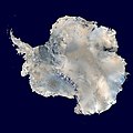
English: Antarctica. An orthographic projection of NASA's Blue Marble data set (1 km resolution global satellite composite). "MODIS observations of polar sea ice were combined with observations of Antarctica made by the National Oceanic and Atmospheric Administration’s AVHRR sensor—the Advanced Very High Resolution Radiometer." Image was generated using a custom C program for handling the Blue Marble files, with orthographic projection formulas from MathWorld.
Note: this image has been manually modified to fill in an area of black pixels in the ocean, in the upper right quadrant. The black pixels are presumed to be due to missing data in the land/sea mask used in making the original Blue Marble image.
Español: El continente antártico. La imagen es una proyección ortogonal creada a partir del conjunto de datos satelitales Blue Marble de la NASA con una resolución de un kilómetro.
Français : Le continent Antarctique. L’image est construite en projection orthographique à partir des données satellites « Blue Marble » de la NASA, ayant une résolution d’un kilomètre. Les images de la banquise, prises par MODIS, ont été combinées avec celles du radiomètre avancé à très haute résolution de la National Oceanic and Atmospheric Administration pour former celle-ci. Elle a été générée en utilisant le logiciel MathWorld.
Note : cette image a été modifiée manuellement pour remplir une zone de pixels noir dans l’océan, dans le coin en haut à droite. Ces pixels manquants sont supposés être dus à des données manquantes dans le masque terre-mer utilisé pour construire l'image original de Blue Marble.
Napulitano: Antartide, vista d’ ’o cielo.
Polski: Antarktyda. Odwzorowanie prostokątne opublikowanego w 2002 roku przez NASA zestawu danych Blue Marble.
مصرى: انتاركتيكا
فارسی: جنوبگان
Українська: Антарктида в ортографічній проекції з роздільною здатністю 1 км, на основі даних супутника MODIS.
Datum
Bron Own work using: 2002 Blue Marble data @ http://visibleearth.nasa.gov/view_rec.php?id=2433
Auteur Dave Pape
Toestemming
(Hergebruik van dit bestand)
Public domain Dit werk vrijgegeven in het publieke domein door de auteur, Davepape. Dit is wereldwijd van toepassing.

In sommige landen is dit wettelijk niet mogelijk; in die gevallen geldt:
Davepape staat iedereen toe dit werk voor eender welk doel te gebruiken, zonder enige voorwaarden, tenzij zulke voorwaarden door de wet worden voorgeschreven.

Andere versies Afgeleide werken van dit bestand:  Antarctic Peninsula satellite image.jpgImage:Antarctica satellite globe.jpg

Onderscheidingen

Afbeelding of the year
Afbeelding van de dag
Uitgelichte afbeelding

Wikimedia CommonsWikipedia

Dit bestand was een finalist bij Afbeelding van het jaar 2013.
Dit bestand was Afbeelding van de dag op (en) , 1.
Dit is een uitgelichte afbeelding op Wikimedia Commons (Uitgelichte afbeeldingen) en wordt beschouwd als een van de beste afbeeldingen.

Wikipedia
 Dit is een uitgelichte afbeelding op de Arabischtalige Wikipedia (صور مختارة) en wordt beschouwd als een van de beste afbeeldingen.
 Dit is een uitgelichte afbeelding op de Engelstalige Wikipedia (Featured pictures) en wordt beschouwd als een van de beste afbeeldingen.
 Dit is een uitgelichte afbeelding op de Perzischtalige Wikipedia (نگاره‌های برگزیده) en wordt beschouwd als een van de beste afbeeldingen.
 Dit is een uitgelichte afbeelding op de Turkstalige Wikipedia (Seçkin resimler) en wordt beschouwd als een van de beste afbeeldingen.

Als u een bestand van vergelijkbare kwaliteit heeft dat kan worden gepubliceerd onder een geschikte copyrightlicentie, upload het dan, voeg een licentie toe, en nomineer het.

Aantekeningen
InfoField
Deze afbeelding is aangetekend: Bekijk de aantekeningen op Commons

Bijschriften

Beschrijf in één regel wat dit bestand voorstelt
The continent of Antarctica, circa 2006.

Items getoond in dit bestand

beeldt af

image/jpeg

affebbaf9a08867a4e4b5329ed0d4959fc866806

3.472.802 byte

6.400 pixel

6.400 pixel

Bestandsgeschiedenis

Klik op een datum/tijd om het bestand te zien zoals het destijds was.

Datum/tijdMiniatuurAfmetingenGebruikerOpmerking
huidige versie5 okt 2006 15:21Miniatuurafbeelding voor de versie van 5 okt 2006 15:216.400 × 6.400 (3,31 MB)Davepapetouched up part with missing data
5 okt 2006 08:49Miniatuurafbeelding voor de versie van 5 okt 2006 08:496.400 × 6.400 (3,31 MB)Davepape{{Information |Description=Antarctica. An orthographic projection of NASA's Blue Marble data set (1 km resolution global satellite composite). "MODIS observations of polar sea ice were combined with observations of Antarctica made by th

Dit bestand wordt op de volgende 3 pagina's gebruikt:

Globaal bestandsgebruik

De volgende andere wiki's gebruiken dit bestand:

Globaal gebruik van dit bestand bekijken.

Metadata

pFad - Phonifier reborn

Pfad - The Proxy pFad of © 2024 Garber Painting. All rights reserved.

Note: This service is not intended for secure transactions such as banking, social media, email, or purchasing. Use at your own risk. We assume no liability whatsoever for broken pages.


Alternative Proxies:

Alternative Proxy

pFad Proxy

pFad v3 Proxy

pFad v4 Proxy