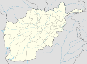
Kabul
Appearance
Kabul کاپل Caubul, Cabul, Cabool | |
|---|---|
Ceety | |
| Coordinates: 34°32′N 69°10′E / 34.533°N 69.167°ECoordinates: 34°32′N 69°10′E / 34.533°N 69.167°E | |
| Kintra | |
| Province | Kabul |
| No. o destricts | 18 |
| Govrenment | |
| • Mayor | Muhammad Yunus Nawandish |
| Area | |
| • Ceety | 275 km2 (106 sq mi) |
| • Metro | 425 km2 (164 sq mi) |
| Elevation | 1791 m (5,876 ft) |
| Population (2011) | |
| • Metro | 3,071,400 |
| • Demonym | Kabuli |
| [1] | |
| Time zone | UTC+4:30 (Afghanistan Staundart Time) |

Kabul (Persie: کابل Kābol IPA: [kɒːˈbol]; Pashto: کابل Kābul IPA: [kɑˈbul];[2] archaic Caubul), is the caipital an lairgest ceety o Afghanistan, locatit in the Kabul Province. Accordin tae the 2008 offeecial estimates, the population o Kabul metropolitan aurie is 2.8 million fowk.[1]
It is an economic an cultural centre, situatit 5,900 ft (1,800 m) abuin sea level in a nairae valley, wedged atween the Hindu Kush muntains alang the Kabul River. The ceety is linked wi Kandahar, Herat an Mazar-e Sharif via a circular hieway that stretches athort the kintra. It is an aa the stairt o the main road tae Jalalabad an faur tae Peshawar, Pakistan.
Sister cities
[eedit | eedit soorce]References
[eedit | eedit soorce]- ↑ a b "Afghanistan Statistical Yearbook 2008/09", Central Statistics Office
- ↑ Pronunciation in Inglis varies, common are /ˈkɑːbəl/, /ˈkɑːbuːl/, an /kəˈbuːl/. See National Review, November 20, 2002, Merriam-Webster: Kabul
| Wikimedia Commons haes media relatit tae Kabul. |
