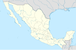
Teteyo el Bajo, General Canuto A. Neri
Izgled
| Teteyo el Bajo | |
|---|---|
| Osnovni podaci | |
| Država | |
| Savezna država | Guerrero |
| Opština | General Canuto A. Neri |
| Stanovništvo | |
| Stanovništvo (2014.) | 96[1] |
| Geografija | |
| Koordinate | 18°27′41″N 100°06′55″W / 18.46144°N 100.1154°W |
| Vremenska zona | UTC-6, leti UTC-5 |
| Nadmorska visina | 883[1] m |
Teteyo el Bajo je naselje u Meksiku, u saveznoj državi Guerrero, u opštini General Canuto A. Neri.
Prema proceni iz 2014. godine u naselju je živelo 96 stanovnika.[1][2] Naselje se nalazi na nadmorskoj visini od 883 m.
- ↑ 1,0 1,1 1,2 „The GeoNames geographical database”. 2015.
- ↑ „Instituto Nacional de Estadística y Geografía”. Aguascalientes, Mexico: INEG.
- Kirkwood, Burton (2005) (engleski). The History of Mexico. Palgrave Macmillan Trade. ISBN 1403962588.
- Enrique Krauze (1998). Mexico: Biography of Power: A history of Modern Mexico 1810–1996. New York: Harper Perennial. ISBN 0-06-092917-0.
- Meyer, Michael C.; Beezley, William H., ur. (2000) (engleski). The Oxford History of Mexico. Oxford University Press. ISBN 0-19-511228-8.
- Santiago, Levy (2008). Good intentions, bad outcomes: Social policy, informality, and economic growth in Mexico. Brookings Institution Press. ISBN 0815752199
- Meyer, Michael C., William L. Sherman, i Susan M. Deeds (2002) (engleski). The Course of Mexican History (7th izd.). Oxford U.P.
- Russell, Philip (2010). The history of Mexico: from pre-conquest to present. Routledge. ISBN 978-0-415-87237-9.
- Werner, Michael S., ur. (1997). Encyclopedia of Mexico: History, Society & Culture. Routledge. ISBN 1884964311
- Werner, Michael S., ur. (2001). Concise Encyclopedia of Mexico. Routledge. ISBN 1579583377
- Mexico entry at The World Factbook
- „Mexico”. UCB Libraries GovPubs.
- Teteyo el Bajo, General Canuto A. Neri na Projektu Open Directory
- „Mexico”. BBC.
- „Mexico”. Encyclopædia Britannica.
 Wikimedia Atlas of Mexico

