Peravia Province
Peravia | |
|---|---|
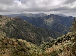
 Bani, Dominican Republic landscape | |
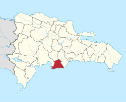
 Location of the Peravia Province | |
| Coordinates: 18°19′48″N 70°22′11″W / 18.33000°N 70.36972°W | |
| Country | |
| Province since | 1944 |
| Capital | Baní |
| Government | |
| • Type | Subdivisions |
| • Body | 3 municipalities 10 municipal districts |
| • Congresspersons | 1 Senator 3 Deputies |
| Area | |
| • Total | 792.33 km2 (305.92 sq mi) |
| Population (2014) | |
| • Total | 217,241 |
| • Density | 270/km2 (710/sq mi) |
| Time zone | UTC-4 (AST) |
| Area code | 1-809 1-829 1-849 |
| ISO 3166-2 | DO-17 |
| Postal Code | 94000 |
Peravia is a province in along the southern coast of the Dominican Republic. The capital city is Baní.
History
[change | change source]The province was created in 1944 with the name of Baní Province, with the municipal district of Nizao, but that same year the name was changed to José Trujillo Valdez Province after the father of dictator Rafael Trujillo. In 1961, the name of the province was changed to the present Peravia. In 1988, Nizao became a municipality in the province.[1]
Matanzas, Villa Fundación and Sabana Buey became municipal districts in 1991; Pizarrete en 1997; Santana and Paya in 1998; Villa Saombrero and El Carretón in 2001; Catalina in 2004; and El Limonal and Las Barías in 2006.[1]
In 2000, the province was divided in two parts and the province of San José de Ocoa was formed with the northern part.
Location
[change | change source]The Peravia province is bordered to the north by the San José de Ocoa province, to the east by the San Cristóbal province, to west by the Azua province and to the south by the Caribbean Sea.
Population
[change | change source]In 2014 (last national census), there were 217,241 people living in the Peravia province, and 125,534 (57.8%) living in towns and cities. The population density was 276.7 persons/km².[2]
Its population represents 2.3% of the total population of the country and the province is ranked as the 16th (out of 31 plus the National District) more populated province.
As of 2016[update], the total estimated propulation of the province is 192,660 inhabitants.[3]
The largest city of the province is Baní, its head municipality or capital, with an urban population (in 2014) of 72,466 inhabitants.[2]
Geography
[change | change source]The Peravia province has a total area of 785.2 km2 (303.2 sq mi).[2] It has 1.6% of the area of the Dominican Republic and it is ranked as the 29th (out of 31 plus the National District) largest province.
The province is along the Caribbean coast, in the eastern part of the Llano Costero del Caribe ("Caribbean Coastal Plain"). There are several small valleys in the southern part of the province, surrounded by the north and west by mountains of the Cordillera Central ("Central mountain range").
The altitude of Baní, provincial capital, is 67 m (220 ft) above sea level.[4]
The most important rivers in the province are the Nizao and Ocoa rivers.
Climate
[change | change source]The climate of the province is tropical dry climate, hot most of the year, but it is cooler on the mountains. It is very dry in the savannas and plains, with long droughts.
Municipalities
[change | change source]There are two municipalities and 11 municipal districts (M.D.) in the province.[1]

| Municipality (code) |
Municipal Districts (code) | Population (2010) |
Area (km2) |
Density | Altitude (m) |
|---|---|---|---|---|---|
| Baní (170101) | 92,153 | 363.3 | 253.7 | 51 | |
| Matanzas (170102) | 16,622 | 118.8 | 139.9 | 76 | |
| Villa Fundación (170103) | 8,811 | 84.8 | 103.9 | 121 | |
| Sabana Buey (170104) | 2,194 | 36.1 | 60.8 | 71 | |
| Paya (170105) | 14,133 | 34.1 | 414.5 | 48 | |
| Villa Sombrero (170106) | 7,954 | 13.3 | 598.0 | 32 | |
| El Carretón (170107) | 4,594 | 14.7 | 312.5 | 165 | |
| Catalina (170108) | 3,436 | 15.0 | 229.1 | 41 | |
| El Limonal (170109) | 4,997 | 45.6 | 109.6 | 233 | |
| Las Barías (170110) | 2,422 | 15.1 | 160.4 | 97 | |
| Baní (170100) | 157,316 | 740.9 | 212.3 | ||
| Nizao (170201) | 13,240 | 17.9 | 739.7 | 29 | |
| Pizarrete (170202) | 6,369 | 12.2 | 522.0 | 57 | |
| Santana (170203) | 7,419 | 14.3 | 518.8 | 50 | |
| Nizao (170200)) | 27,028 | 44.3 | 610.1 | ||
| Peravia (170000) | 217,241 | 785.2 | 276.7 | ||
Economy
[change | change source]The main economic activity in the province is farming, growing fruits (like mangos) and vegetables (tomatoes and onions). Fishing and salt production is also important along the Caribbean Sea and there are some factories in Baní.
References
[change | change source]- ↑ 1.0 1.1 1.2 "División Territorial 2015" (in Spanish). Oficina Nacional de Estadística (ONE). October 2015. Archived from the original (PDF) on 14 November 2015. Retrieved 20 November 2016.
- ↑ 2.0 2.1 2.2 Consejo Nacional de Población y Familia. "Estamaciones y Proyecciones de la Población Dominicana por Regiones, Provincias, Municipios y Distritos Municipales, 2014" (PDF) (in Spanish). Retrieved 2014-02-02.
- ↑ "REPÚBLICA DOMINICANA: Población por año calendario, según sexo y grupos quinquenales de edad, 2015-2020" (in Spanish). Oficina Nacional de Estadística (ONE). Archived from the original (XLS) on 24 June 2016. Retrieved 20 November 2016.
- ↑ "Baní". Geonames.org. Retrieved 20 November 2016.
