St. Augustine, Florida
St. Augustine | |
|---|---|
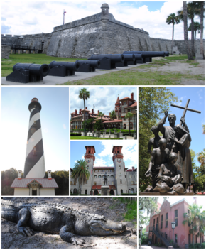
 Top, left to right: Castillo de San Marcos, St. Augustine Light, Flagler College, Lightner Museum, statue near the Cathedral Basilica of St. Augustine, St. Augustine Alligator Farm Zoological Park, Old St. Johns County Jail | |
| Nickname(s): Ancient City, Old City | |
 Location in St. Johns County and the U.S. state of Florida | |
| Coordinates: 29°53′41″N 81°18′52″W / 29.89472°N 81.31444°W[1] | |
| Country | United States |
| State | Florida |
| County | St. Johns |
| Established | September 8, 1565 |
| Founded by | Pedro Menéndez de Avilés |
| Named for | Saint Augustine of Hippo |
| Government | |
| • Type | City commission government |
| Area | |
| • City | 12.85 sq mi (33.29 km2) |
| • Land | 9.52 sq mi (24.66 km2) |
| • Water | 3.33 sq mi (8.63 km2) |
| Elevation | 0 ft (0 m) |
| Population | |
| • City | 14,329 |
| • Density | 1,504.99/sq mi (581.05/km2) |
| • Urban | 91,786 |
| Time zone | UTC−5 (EST) |
| • Summer (DST) | UTC−4 (EDT) |
| ZIP code(s) | 32080, 32084, 32085, 32086, 32095, 32082, 32092 |
| Area code | 904 |
| FIPS code | 12-62500[5] |
| GNIS feature ID | 0308101[3] |
| Website | City of St. Augustine |
St. Augustine is the oldest city in the United States begun by Europeans and filled with people since it was started. The admiral from Spain, Pedro Menéndez de Avilés, started St. Augustine in 1565. There was fighting between England and Spain in 1586, 1702, and 1740 over the city. Spain won each time. In 1763, St. Augustine was given to the English as part of the Treaty of Paris which ended the French and Indian War. After the American colonies became independent from England, another Treaty of Paris, this one in 1783, returned the area to Spain. In 1819, the Adams-Onís Treaty gave all of Florida to the United States.
The largest sign of the years under Spain is the Castillo de San Marcos, a large masonry fort built between 1672 and 1695. This fort still stands.
References
[change | change source]- ↑ "GNIS Detail – Saint Augustine". geonames.usgs.gov. Geographic Names Information System. 2011-02-12. Retrieved 2011-04-23.[permanent dead link]
- ↑ "2020 U.S. Gazetteer Files". United States Census Bureau. Retrieved October 31, 2021.
- ↑ 3.0 3.1 "US Board on Geographic Names". geonames.usgs.gov. United States Geological Survey. October 25, 2007. Archived from the original on February 12, 2012. Retrieved January 31, 2008.
- ↑ "QuickFacts: St. Augustine city, Florida". United States Census Bureau. Retrieved September 15, 2023.
- ↑ "U.S. Census website". census.gov. United States Census Bureau. Retrieved 2008-01-31.
Other websites
[change | change source]![]() Media related to St. Augustine, Florida at Wikimedia Commons
Media related to St. Augustine, Florida at Wikimedia Commons

