Dobruška
Wygląd
Spůłrzyndne: 50°17'31" N 16°09'36" E![]()
| Dobruška | |||||
| |||||
 Dobruška | |||||
| Państwo | |||||
| Krej | Hradecki | ||||
| Starosta | Petr Lžíčař | ||||
| Plac | 34,43 km² | ||||
| Położyńe | 50°17'31'' N 16°09'36'' E | ||||
| Wysokość | 287 m n.p.m. | ||||
| Ludźi (2020) • liczba ludźi • gynstość |
6723 195,3 uos./km² | ||||
| Pocztowy kod | 518 01 | ||||
| Mjasta partnerske | |||||
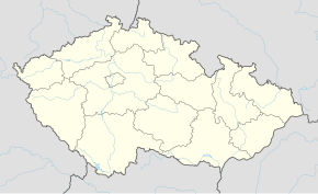
Położyńe na karće kraju
| |||||
| Neczajta mjasta | |||||
Dobruška (mjym. Gutenfeld) – sztad we půłnocnyj tajli Czeskij Republiki, we hradeckim kreju, we kryśe Rychnov nad Kněžnou.


