త్రిపుర
ఈ వ్యాసాన్ని ఏ మూలాల నుండి సేకరించిన సమాచారాన్ని ఆధారంగా చేసుకొని వ్రాసారో తెలపలేదు. సరయిన మూలాలను చేర్చి వ్యాసాన్ని మెరుగు పరచండి. ఈ విషయమై చర్చించేందుకు చర్చా పేజీని చూడండి. |
ఈ వ్యాసం లేదా వ్యాసభాగాన్ని విస్తరించవలసి ఉంది. సముచితమైన సమాచారంతో వ్యాసాన్ని విస్తరించండి. విస్తరణ పూర్తయిన తర్వాత, ఈ నోటీసును తీసివేయండి. |
Tripura | ||||||
|---|---|---|---|---|---|---|
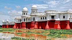
(clockwise from top) Ujjayanta Palace; Tripura Sundari Temple; Neermahal palace; rock-cut sculptures at Unakoti | ||||||
| Etymology: Land near water | ||||||
| Nickname: "Hill Tipperah" | ||||||
| Motto(s): Satyameva Jayate (Truth alone triumphs) | ||||||
 Location of Tripura in India | ||||||
| Coordinates: 23°50′N 91°17′E / 23.84°N 91.28°E | ||||||
| Country | ||||||
| Region | Northeast India | |||||
| Before was | Princely state of Tripura | |||||
| Admission to Union | 15 October 1949[1] | |||||
| As Union territory | 1 November 1956 | |||||
| Formation (as a state) | 21 January 1972 | |||||
| Capital and largest city | Agartala | |||||
| Districts | 8 | |||||
| Government | ||||||
| • Body | Government of Tripura | |||||
| • Governor | Nallu Indra Sena Reddy[2] | |||||
| • Chief Minister | Manik Saha (BJP) | |||||
| • Chief Secretary | J.K Sinha[3] | |||||
| State Legislature | Unicameral | |||||
| • Assembly | Tripura Legislative Assembly (60 seats) | |||||
| National Parliament | Parliament of India | |||||
| • Rajya Sabha | 1 seat | |||||
| • Lok Sabha | 2 seats | |||||
| High Court | Tripura High Court | |||||
| విస్తీర్ణం | ||||||
| • Total | 10,491 కి.మీ2 (4,051 చ. మై) | |||||
| • Rank | 28th | |||||
| Dimensions | ||||||
| • Length | 178 కి.మీ (111 మై.) | |||||
| • Width | 131 కి.మీ (81 మై.) | |||||
| Elevation | 780 మీ (2,560 అ.) | |||||
| Highest elevation | 3,051 మీ (10,010 అ.) | |||||
| Lowest elevation (Western Part) | 15 మీ (49 అ.) | |||||
| జనాభా (2023)[6] | ||||||
| • Total | ||||||
| • Rank | 23rd | |||||
| • Urban | 39.19% | |||||
| • Rural | 60.81% | |||||
| Demonym | Tripuran | |||||
| Language | ||||||
| • Official | [7] | |||||
| • Official Script | ||||||
| GDP | ||||||
| • Total (2020–2021) | ||||||
| • Rank | 24th | |||||
| • Per capita | ||||||
| Time zone | UTC+05:30 (IST) | |||||
| ISO 3166 code | IN-TR | |||||
| Vehicle registration | TR | |||||
| HDI (2022) | ||||||
| Literacy (2013) | ||||||
| Sex ratio (2023) | 967♀/1000 ♂ (2nd) | |||||
| Symbols of Tripura | ||||||
 Emblem of Tripura | ||||||
| Language | [7] | |||||
| Foundation day | Tripura Day | |||||
| Bird | Green imperial pigeon | |||||
| Fish | Pabda | |||||
| Flower | Indian rose chestnut | |||||
| Fruit | Queen pineapple | |||||
| Mammal | Phayre's leaf monkey | |||||
| Tree | Agarwood | |||||
| State Highway Mark | ||||||
 | ||||||
| State Highway of Tripura | ||||||
| List of State Symbols | ||||||
| †It was elevated from the status of Union territory by the North-Eastern Areas (Reorganisation) Act 1971 | ||||||
త్రిపుర (Bengali: ত্রিপুরা) ఈశాన్య భారతదేశం లోని రాష్ట్రం. రాష్ట్ర రాజధాని అగర్తాల, ఇక్కడ మాట్లాడే ప్రధాన భాషలు బెంగాళీ, కోక్బరోక్. త్రిపుర రాష్ట్ర శాసనసభకు 60 శాసనసభ నియోకవర్గాలు ఉన్నాయి
చరిత్ర
[మార్చు]త్రిపుర స్వాతంత్ర్యానికి మునుపు ఒక రాజ్యంగా ఉండేది. 1949 లో భారతదేశంలో విలీనమయ్యేవరకు గిరిజన రాజులు మాణిక్య అనే పట్టణంతో త్రిపురను శతాబ్దాలుగా పరిపాలించారు. వీరి రాజ్యం రాజధాని దక్షిణ త్రిపురలో గోమతీ నది తీరాన రంగమతిగా పేరుపొందిన ఉదయపూర్ లో ఉంది. రాజధానిని తొలుత పాత అగర్తాలకు ఆ తర్వాత 19వ శతాబ్దంలో ప్రస్తుత అగర్తాలాకు తరలించబడింది. రాచరిక పరిపాలనకు వ్యతిరేకంగా గణముక్తి పరిషద్ ఉద్యమం ప్రారంభమైంది. ఈ ఉద్యమ విజయానికి ఫలితంగా త్రిపుర భారతదేశంలో విలీనమైంది. దేశ విభజన తీవ్ర ప్రభావం చూపిన ప్రాంతాలలో త్రిపుర కూడా ఒకటి. రాష్ట్రంలో ఇప్పుడు బెంగాళీలు (ఇందులో చాలామంది 1971లో బంగ్లాదేశ్ యేర్పడిన తర్వాత పారిపోయి ఇక్కడ ఆశ్రయం పొందిన వారే) స్థానిక గిరిజనులు పక్కపక్కనే సహజీవనం సాగిస్తున్నారు.1970 దశాబ్దం చివరి నుండి త్రిపురలో సాయుధ ఘర్షణ కొనసాగుతుంది.
రాజకీయాలు
[మార్చు]త్రిపుర రాష్ట్రాన్ని ప్రస్తుతం విప్లవ్ కుమార్ ముఖ్యమంత్రిగా భా.జ.పా పరిపాలిస్తుంది. 1977 వరకు రాష్ట్రాన్ని కాంగ్రేసు పార్టీ పరిపాలించింది. 1978 నుండి 1988 వరకు వామపక్ష కూటమి పరిపాలించి, తిరిగి 1993లో అధికారములోకి వచ్చింది. 1988 నుండి 1993 వరకు భారత జాతీయ కాంగ్రేసు, త్రిపుర ఉపజాతి యుబ సమితి సంకీర్ణ ప్రభుత్వం పాలించింది.2018లో జరిగిన ఎన్నికలలో అప్పటి వరకు ఉన్న వామపక్ష కోటను బద్దలుకొట్టి భాజపా అధికారంలోకి వచ్చింది.
మూలాలు
[మార్చు]- ↑ "Historical Background | Tripura State Portal".
- ↑ "Shri Satyadeo Narain Arya Hon'ble Governor of Tripura". tripura.gov.in. Retrieved 3 March 2022.
- ↑ "CS Profile | Tripura State Portal".
- ↑ "Know Tripura | Tripura State Portal". tripura.gov.in. Retrieved 23 December 2020.
- ↑ "Betalongchhip - Peakbagger.com". www.peakbagger.com. Retrieved 24 March 2023.
- ↑ Population Projections for India and States, 2011-2036. July 2020.
- ↑ "Report of the Commissioner for linguistic minorities: 52nd report (July 2014 to June 2015)" (PDF). Commissioner for Linguistic Minorities, Ministry of Minority Affairs, Government of India. pp. 79–84. Archived from the original (PDF) on 15 November 2016. Retrieved 16 February 2016.
{{cite web}}: More than one of|archivedate=and|archive-date=specified (help); More than one of|archiveurl=and|archive-url=specified (help) - ↑ "Sub-national HDI – Area Database". Global Data Lab (in ఇంగ్లీష్). Institute for Management Research, Radboud University. Archived from the original on 23 September 2018. Retrieved 25 September 2018.
- ↑ "Tripura beats Kerala in literacy", The Times of India, timesofindia.indiatimes.com, 8 September 2013, retrieved 8 September 2013
{{citation}}: CS1 maint: url-status (link)


